Kayaking on the Norfolk Broads
The Norfolk Broads represent a network of navigable waterways (eponymously in Norfolk) that were created in medieval times by peat digging. The depressions later filled with water so that the rivers connecting them broadened out (hence, Broads) - see also the map at the bottom of this post.

Top left arrow (red) the English Lake District is where I live; lower right arrow (black) the Norfolk Broads where I visited.
The Norfolk Broads represent an important water-based recreational area for boating, fishing, etc. and is a major wildlife conservation area.
 Near inhabited areas there are houses that border the waterfront. This desirable property for sale comes with included boathouse and fishing rights.
 Hmmm. Maybe if I win the lottery...
 Popular for boating holidays, the rivers can become a little congested near the busy marinas...
 ...but there are secluded conservation areas accessible only to kayaks
On my first day, I decided to familiarise myself with Broadland life by participating in a guided canoe trail with The Canoe Man, when I met up with and a shared a canoe with fellow blogger Ellee Seymour at South Walsham Broad.
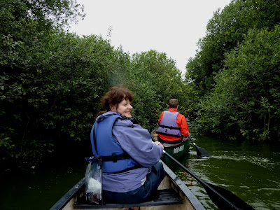 Ellee Seymour glances over her shoulder,
maybe to warn me that I am about to steer the canoe into the bushes!
 The next morning at daybreak, I find myself exploring the deserted Hoveton Little Broad...
 ...in the rain. But who cares, this is an adventure!
More adventures in the Norfolk Broads in Part 2!
 The Norfolk Broads - a navigable network of waterways created by peat digging in medieval times. The black edging down the right side is the Norfolk coastline.
posted by Maalie at 7:52 am
11 comments
![]()
![]()


